
INDIA (BHARAT)
General lay out:
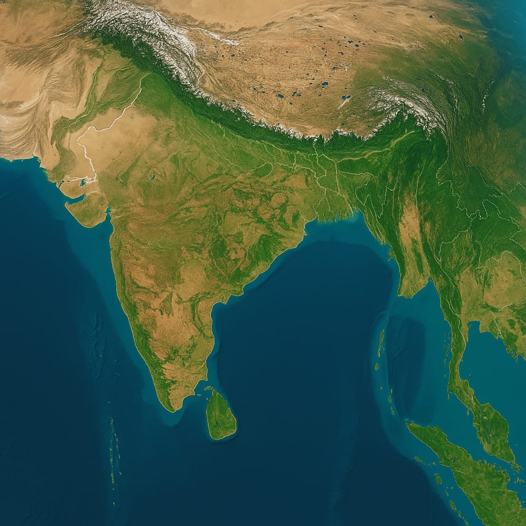
India, officially known as Bharat, is the seventh-largest country in the world by area and the second most populous nation. Bounded by the majestic Himalayas and other snow-covered mountain ranges to the north, India stretches southward, narrowing near the Tropic of Cancer before tapering off into the Indian Ocean, between the Bay of Bengal on the east and the Arabian Sea on the west. The country lies entirely in the Northern Hemisphere, with its mainland extending between latitudes 8°4′N and 37°6′N, and longitudes 68°7′E and 97°25′E. It measures approximately 3,214 kilometers from north to south and about 2,933 kilometers from east to west, covering a total area of 3,287,263 square kilometers. India shares a land frontier of about 15,200 kilometers and has a mainland coastline of approximately 6,100 kilometers
Our Neighbours:
India is bounded by the mighty Himalayan ranges and other high mountain systems in the north. In the extreme northwest, it is bordered by the Karakoram range, including parts of the Aghil and Kunlun mountains near Kashmir and Ladakh. The Zaskar range forms part of its northern barrier in the region of Himachal Pradesh and Ladakh. To the north, India shares international borders with China, Nepal, and Bhutan. In the east, it is bordered by Bangladesh, which is surrounded by the Indian states of West Bengal, Assam, Meghalaya, Tripura, and Mizoram, as well as by Myanmar (Burma). In the northwest, India shares borders with Pakistan and a small boundary with Afghanistan. In the south, the Gulf of Mannar and the Palk Strait separate India from Sri Lanka. Additionally, the Andaman and Nicobar Islands in the Bay of Bengal and the Lakshadweep Islands in the Arabian Sea are integral parts of Indian territory.
The Physical characteristics of India
The mainland consists of four well-defined regions:
(i) the Great Mountain Zone
(ii) the Indo-Gangetic Plain
(iii) the Desert Region
(iv) the Southern Peninsula
The Himalayas comprise three almost parallel ranges, interspersed with large plateaus and valleys of great scenic beauty, and include some of the world’s highest peaks. The high altitudes limit travel to a few passes, notably the Jelep La and Nathu La — important Indo-Tibet trade routes through the Lachung Valley northeast of Darjeeling — and the Shipki La in the Sutlej Valley northwest of Kalpa (Kinnaur). This mountain wall stretches over about 2,400 km, with a depth varying between 240 and 320 km. In the eastern regions bordering Myanmar and Bangladesh, the hills are much lower, including the Garo, Khasi, Jaintia, and Naga Hills, which run east-west and join the Lushai and Arakan Hills running north-south.
The Indo-Gangetic Plain, approximately 2,400 km long and 240 to 320 km wide, is formed by the basins of three major river systems: the Indus, the Ganges, and the Brahmaputra. It is one of the world’s largest expanses of flat alluvium and among the most densely populated areas on Earth; between Delhi’s Yamuna River and the Bay of Bengal, nearly 1,600 km away, there is only a 200-meter drop in elevation.
The desert region is divided into two parts: the Great Desert, extending from the edge of the Rann of Kutch beyond the Luni River northward along the Rajasthan-Sind frontier, and the Little Desert, stretching from the Luni River between Jaisalmer and Jodhpur up to the northern barren lands. Between them lies a zone of almost completely sterile country, characterized by rocky land cut by limestone ridges. Due to the absence of surface water and very scanty rainfall, this region is nearly entirely barren.
Rivers of India
The rivers of India may be classified into four groups: (a) the Himalayan rivers, (b) the Deccan rivers, (c) the coastal rivers, and (d) the rivers of the inland drainage basin. The Himalayan rivers are generally snow-fed and therefore have a continuous flow throughout the year. During the monsoon months, the Himalayas receive very heavy precipitation, and the rivers discharge their maximum volume of water during this season, often causing floods. The Deccan rivers are mainly rain-fed and, as a result, fluctuate greatly in volume. A large number of these streams are non-perennial. The coastal streams, especially those on the west coast, are short in length and have limited catchment areas; most of them are also non-perennial. The streams in the inland drainage basin of western Rajasthan are few and far between and are mostly ephemeral in character. They drain towards individual basins or into the Sambhar Salt Lake, or they disappear into the sands without reaching the sea. Only the Luni River drains into the Rann of Kutch.
The Ganga basin, which receives waters from numerous tributaries, forms the largest river basin in India, covering about one-quarter of the country’s total area. It is bounded by the Himalayas in the north and the Vindhya mountains in the south. The Ganga has two main headwaters in the Himalayas: the Bhagirathi, originating from the Gangotri Glacier near Gaumukh, and the Alaknanda, which begins at the Alkapuri Glacier. Several major Himalayan tributaries, including the Yamuna, Ghaghra, Gandak, and Kosi, merge into the Ganga. The Yamuna, which rises from the Yamunotri Glacier, joins the Ganga at Allahabad (now called Prayagraj) and is the westernmost river in the Ganga river system. Additionally, rivers from central India such as the Chambal, Betwa, and Sone flow northward to join either the Yamuna or the Ganga, further enriching this vast river network.
India’s second-largest river basin by area is the Godavari, which covers nearly 10% of the country’s landmass. To its east lies the Brahmaputra basin and to the west, the Indus basin — both of which are roughly equal in size. In southern India, the Krishna River drains the second-largest basin, while the Mahanadi River flows through the third-largest. Although smaller and differing in shape and terrain, the Narmada and Cauvery basins are comparable in size to each other.
Climatic Conditions
Four seasons are recognized are by the Indian meteorological department. They are
(i)The cold weather (December-March);
(ii) The hot weather (April-May);
(iii) The rainy season (June. September) and
(iv) The season of the retreating South-west monsoon (October-November).
Based on rainfall, India can be divided into four broad climatic regions. Practically the whole of Assam and the west coast of India, lying at the foot of the Western Ghats and extending from north of Mumbai to Thiruvananthapuram, are areas of very heavy rainfall. In contrast, the Rajasthan desert extending to Kutch and the high Ladakh plateau of Kashmir extending westward to Gilgit are regions of low precipitation. Between these two extremes lie areas of moderately high and moderately low rainfall. The region of moderately high rainfall includes a broad belt in eastern India, covering Odisha, Jharkhand, Chhattisgarh, eastern Madhya Pradesh, and parts of Bihar and West Bengal. The areas of moderately low rainfall cover the interior parts of the Deccan plateau and some regions in the leeward side of the Western Ghats.the eastern part of the peninsula merges northward with the Indian plain and southward with the coastal plains. This region forms a transitional belt extending from the Punjab plains across the Vindhya mountains into the western part of the Deccan plateau, widening considerably in the Mysore plateau. It connects the eastern part of the peninsula with both the northern plains and the coastal plains, creating a continuous stretch of land that blends different geographic and climatic features. This belt represents an area of moderately high rainfall, lying between regions of very heavy precipitation in the northeast and along the Western Ghats, and the arid or semi-arid zones of Rajasthan and the Deccan interior. Thus, it serves as an important climatic and geographical transition zone in India.
Principal languages
Telugu, Hindi, Assamese, Bengali, Gujarati, Kannada, Kashmiri, Malayalam, Marathi, Oriya, Punjabi, Sanskrit, Sindhi, Tamil, and Urdu are among the major languages spoken in India. Hindi is the official language, while English is recognized as an associate official language. In addition to Hindi, the Constitution recognizes 14 other national languages, as listed above, although as many as 1,652 languages and dialects are spoken across the country. Hindi is spoken by about 38% of the population, followed by Telugu (9%), Bengali (8%), Marathi (8%), Tamil (7%), Urdu (6%), Gujarati (5%), Kannada (4%), Punjabi (3%), Oriya (3%), and Malayalam (3%).
Histri -Indian history knowledge blog
know the facts